
Dawson Creek to Whitehorse: Our Alaska Highway Phase 1

Just the idea of driving the Alaska Highway sounded like an adventure to us. There’s something about being able to actually drive to the start of it from our Florida home that feels wildly different than flying in and “starting” the trip once you land.
This stretch felt remote in a way that’s hard to explain until you’re in it—wilderness, wide-open scenery, and that “we are very far from our normal life” feeling. Not like Yellowstone or Glacier where you can be back in familiar civilization after a few hours. This felt like the real deal.
Dawson Creek: Mile 0 - The Adventure Begins!

Dawson Creek is the official start of the Alaska Highway—Mile Marker 0—and honestly, just getting there is its own long-haul commitment. We had driven over 3,500 miles just in the RV – not counting the thousands of “side trip” miles in the truck - By the time we finally rolled in to Mile 0, we got an unmistakable vibe of adventure. All new territory for us from here on!
We were struck by the common thread bonding everyone at Dawson Creek - there was a natural camaraderie. Everyone seems to be either coming from Alaska or heading to it, and there’s this unspoken club feeling—like you’re all in on an out of the ordinary adventure commitment. Not that all the travelers were the same – far from it! While the predominant age was over 40 – there were still some younger people and families with small children. Motorcycles, Truck campers,vans, trailers of every shape and size, 5th wheels, Class c’s & A’s and the occasional large“All terrain” vehicles often from Germany and Switerzland.
Chatting it up
Almost everyone loved to chat. There were the classic travelers like us who’d done a lot of RVing and were chasing a new adventure. There were the rental RVers who had no clue how to operate their rig (or how to drive it), and they were usually the same ones confidently announcing they planned to cover 500 miles a day—like this is just a normal freeway road trip. Then there were the “repeaters,” the folks who come back year after year, often for one very compelling reason: fishing in Alaska.
But no matter what kind of traveler they were, people seemed genuinely happy to swap stories and share what they’d learned so far.
And then there’s one group I almost forgot to mention—the cyclists. They horrified and amazed me in equal measure. They’re out there—old and young—cold, wet, climbing over sheer mountains (these are not hills), often with no shoulder, with semi trucks and quasi-locals flying by way over the speed limit… while tourists are busy rubbernecking at the scenery. CRAZY pretty much sums it up. Often we would pass them and just think “why?”. In truth were equal parts horrified, curious and impressed.
Fort St. John + Charlie Lake: when “the vision” meets two days of rain
We camped a little past Fort St. John at Charlie Lake. Here’s the thing about trip planning: the version in my head is almost never the version in real life. Sometimes it’s better. Sometimes it’s worse. Often it’s just… different.
In this case, two straight days of rain turned our campground into a glorified mud parking lot. A soupy mess. The good news: there was enough gravel underneath that we didn’t get stuck. The better news: Fort St. John felt familiar enough (and civilized enough) that I made the best of a rainy day and got a pedicure. Priorities.
Fort St. John was founded as a trading post in 1794, which makes it the oldest European-established settlement in British Columbia. With around 21,000 people, it was a nice little “reset” before we pushed farther north.
Fort Nelson (Mile 300): where the trip starts to feel like the point

Fort Nelson (Mile Marker 300) is called the Gateway to the Northern Rockies, and that’s where I’d say the scenery started changing faster—and the whole trip shifted.
From here, it stopped feeling like we were going to the next place. We were already in it. The journey became the destination (which sounds like a motivational poster, but it’s true).
There was an interesting "museum" more like a barn but with lots of interesting cars.
Stone Mountain Provincial Park + Muncho Lake: top-tier scenery (and a few white-knuckle moments)

Looking back on the drive from Dawson Creek to Whitehorse, this section is absolutely at the top for scenery.
Stone Mountain Provincial Park was beautiful… and also a little treacherous. The mountains and drop-offs were stunning for me as the passenger. Manny might describe it with different words. There were great hiking trails and areas where we would have pulled off and just taken it in – but the RV size and sheer cliffs didn’t allow for us safely to do so. We were a little too far once we got to our next stop to drive almost 75 miles to back track – so we are noting this area as a future place to “slow it down” and explore in the truck next time.

Muncho Lake

And then Muncho Lake. Dropping down into that area was one of those “how did they even build this highway?” moments. The lake is huge and shockingly blue, and the highway curves close to it along the inside of the mountain.
We were able to pull our 65’ train into one of the pullouts (thank goodness for those) and spent a few hours there having lunch, fishing, and just soaking it in. It was one of those stops that didn’t feel rushed—which is exactly how we like to travel. One of the things that we really love is that on the Alaskan highway there are numerous sites that we can pull into and just stop for a few hours or even for the night Muncho Lake was a little like “hotel California” we had to pull ourselves away or we may have ended up staying much longer than our itinerary planned for.

Liard Hot Springs: the surprise highlight I’d actually do again
We took a side trip to Liard Hot Springs, which is not always our thing. We’ve seen hot springs that feel like a rustic jacuzzi situation where you’re basically shoulder-to-shoulder with strangers. Not my favorite.
Liard was different.

It starts with a quarter-mile walk on a wooden boardwalk through boreal forest, and it almost felt tropical in a weird way. The weather was still chilly (mid-50s), but the sun was out—perfect timing.
The springs themselves felt natural and non-commercial, with modest changing rooms, a comfortable entry area, and enough space to spread out. The water was lovely (a little too warm in spots), but you can move around and find the temperature that works.
This ended up being one of the best unexpected highlights of our Alaska Highway experience so far. They are open year round and I could only imagine tromping through the snow and hustling out of the changing rooms and jumping into the springs! Maybe on a future Northern Lights trip?
Watson Lake: Sign Post Forest + a very memorable stop at “Nugget City”
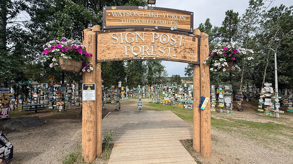
Watson Lake is home to the iconic Sign Post Forest—thousands of signs from all over the world posted in the middle of what feels like nowhere. It started when a soldier put up a sign with his hometown “for fun,” and it just kept growing. We had fun finding signs that were close to where we lived – couldn’t help wondering how many (most) of these signs were procured.
We spent the night not far from Watson Lake at Nugget City, which is basically one business run by an enterprising family. It was Canada Day, the employees were all on holiday, and the owner was doing everything: running the café, renting RV spaces, selling gas, and walking people over to peek into the gift shop! It’s the type of hustle you have to have to make it work I think as we drove by several similar establishments on the journey that were closed this year due to employee shortages. Living and working here was not for the faint of heart.
Wildlife: a few great sightings… and a little disappointment

From Watson Lake, we headed toward Whitehorse and finally saw a herd of wood bison lounging next to the highway. They’re bigger than the bison you see in Yellowstone—different breed, different presence.
We also caught glimpses of a fox and a little black bear. But overall, we didn’t see as much wildlife as we expected after leaving Banff and Jasper.
We’re usually pretty lucky with animal sightings, so this was one of the few “huh, really?” parts of the drive.
Whitehorse: an oasis in the wilderness

Arriving in Whitehorse felt like landing in an oasis. With around 35,000 residents, it’s the largest city across three northern territories (Yukon, Northwest Territories, and Nunavut). And yet it still feels surrounded by wilderness—mountains, wide skies, and the untamed Yukon River running right through town. So for us the town was the best of both worlds – modern but not really.
Whitehorse also has an airport with commercial flights (small jets) to major connection cities like Seattle and Calgary, and that alone tells you how important it is as a hub. Granted it would be some work – several flights and lots of time - to get a flight here from Sarasota but still possible. Northern Lights in February?
Just so you can put it into perspective – Whitehorse has hospital, major services etc. you are several hundreds of miles (long driving days away) from the next place that can provide these things! It dawns on me that yes there are many places in the world that are more isolated but not any places that I have been!
For our trip, Whitehorse became a central base. We went Whitehorse → Dawson City → Whitehorse, then down to Haines, Alaska → back to Whitehorse. We ended up with three separate stays here, and every time we left feeling like we could’ve done more.
Hiking + trails -Whitehorse

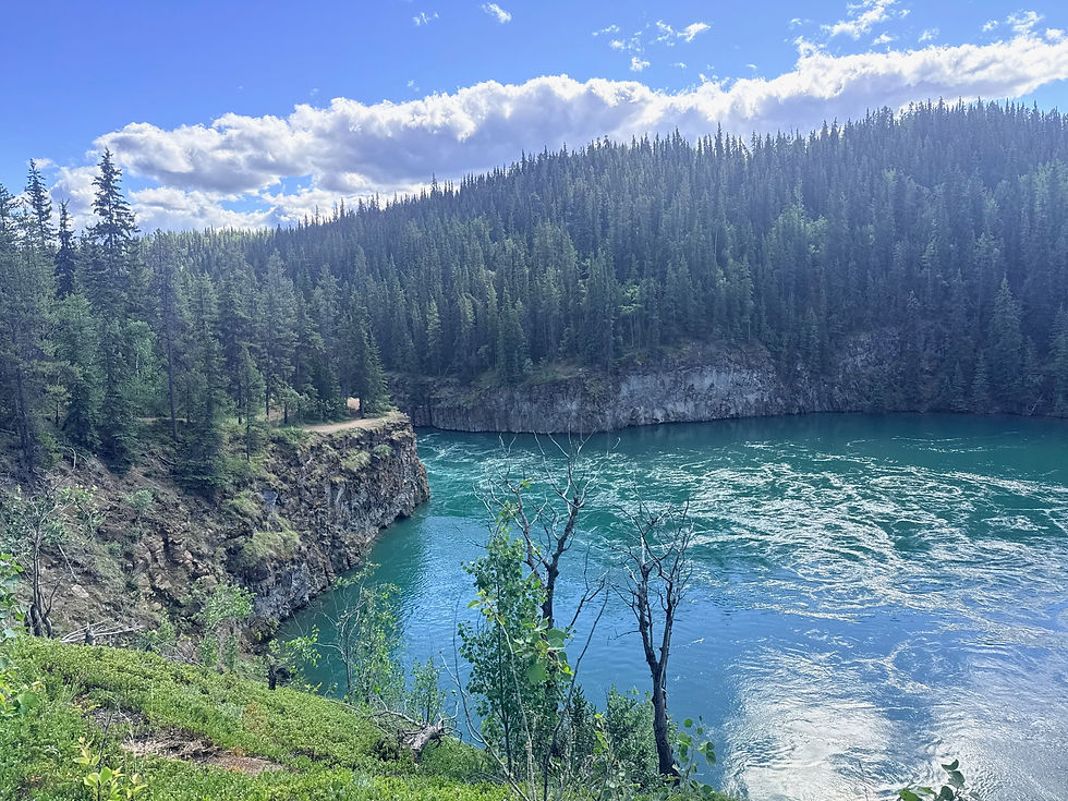
Whitehorse still feels outdoorsy even near the center. The river has great walking trails, and Miles Canyon is a favorite—crossing the suspension bridge and following the river for miles. The water is a surprising shade of blue and moves with real force as it crashes through the canyon. Great hike with a surprising amount of hikers on a beautiful Saturday but we still were able to walk away from the majority of people after that extra mile.


Up next
This Dawson Creek to Whitehorse stretch which includes the “Top of the World” and “Tombstone” side trips. Hint: the Klondike - Worst highway we have ever driven the RV on!” Some of the most amazing scenery including a stop in Chicken, Alaska.


Comments